Demonstrations, Live Training, and Hackathon Winners Show the Power of GIS
REDLANDS, Calif. — (BUSINESS WIRE) — May 10, 2016 — Today, Esri, the world leader in geographic information system (GIS) solutions, announced that it will be exhibiting and providing a free training session at GEOINT, May 15 to 18, 2016, in Orlando, Florida. Esri will be showcasing transformational geospatial technologies, based on the ArcGIS platform, that provide advanced analytics and mission-focused enhancements for defense, intelligence, and national security workflows.
This Smart News Release features multimedia. View the full release here: http://www.businesswire.com/news/home/20160510005511/en/

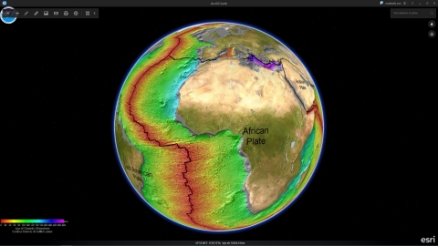
At GEOINT, Esri will highlight advanced analytics and visualization tools including ArcGIS Earth and Insights for ArcGIS. (Graphic: Business Wire)
Esri staff will be on-site to discuss the ways the ArcGIS platform is enabling customers to deliver the actionable intelligence on which decision makers rely. An integrated platform for defense, intelligence, and national security, ArcGIS provides high-performance 2D and 3D analysis. It is a complete and open technology (or platform) for managing, analyzing, and sharing data and products. ArcGIS leverages big data, web technologies, and integrated apps to make GIS easy to use, more accessible, and collaborative.
"The national security community can benefit from visual exploration of enterprise data, regardless of source," said John Day, director of national security, business development, at Esri. "At this event, we will demonstrate how spatiotemporal analyses provide quick, responsive, and interactive experiences that increase productivity to support decision making and operations."
-
Who
- Jeff Peters—Director, Global Business Development, National Government Sector, Esri
- Patty Mims—Deputy Director, Global Business Development, National Government Sector, Esri
- Brian Lehman—Director, Defense, Business Development, Esri
- Chris Albert—Director, Intelligence, Business Development, Esri
- John Day—Director, National Security, Business Development, Esri
- What: GEOINT, booth #600
- Where: Orlando, Florida
- When: May 15–18, 2016
-
Activities
-
Booth Demonstrations
- Insights for ArcGIS—Advanced analytics
- Military Tools for ArcGIS—A collection of new mission-focused enhancements for defense and intelligence workflows in ArcGIS
- 2D and 3D Visualization—ArcGIS Earth and ArcGIS Pro
- Advanced Imagery and Full-Motion Video Capabilities—Drone2Map for ArcGIS
- Developer Tools and Apps—May 10, 2016, App Challenge Winner showcase
-
Training—Technical Applications for Geospatial Intelligence
- Presenter: Carl Eichenberger, May 18, 2016, 7:00 a.m.–9:00 a.m.
-
Booth Demonstrations
Learn to evaluate and prepare geospatial data for use in geospatial intelligence (GEOINT) fusion, analysis, and intelligence products. Perform different types of geospatial analyses (including terrain, raster-based, viewshed, and temporal) to evaluate potential threats and identify patterns, hot spots, and clusters. Evaluate suitability of multiple locations for tactical operations and understand how the creation of operational map products aids in improving outcomes.
Learn more about Esri solutions for the defense and intelligence markets.
About Esri
Since 1969, Esri has been giving customers around the world the power to think and plan geographically. The market leader in GIS technology, Esri software is used in more than 350,000 organizations worldwide including each of the 200 largest cities in the United States, most national governments, more than two-thirds of Fortune 500 companies, and more than 7,000 colleges and universities. Esri applications, running on more than one million desktops and thousands of web and enterprise servers, provide the backbone for the world's mapping and spatial analysis. Esri is the only vendor that provides complete technical solutions for desktop, mobile, server, and Internet platforms. Visit us at esri.com/news.
Copyright © 2016 Esri. All rights reserved. Esri, the Esri globe logo, GIS by Esri, ArcGIS, @esri.com, and esri.com are trademarks, service marks, or registered marks of Esri in the United States, the European Community, or certain other jurisdictions. Other companies and products or services mentioned herein may be trademarks, service marks, or registered marks of their respective mark owners.
View source version on businesswire.com: http://www.businesswire.com/news/home/20160510005511/en/
Contact:
Esri
Karen Richardson, 909-793-2853, extension 1-3491
Email Contact