Common Information Model Would Identify Real-Time Regional Outage Data during Power Restoration Efforts
Redlands, CA, March 3, 2015 — Last year the White House Office of Science and Technology Policy (OSTP) challenged software providers and electric utilities to find a common communication platform that fostered power restoration after storms. This year, geographic information system (GIS) technology provider Esri and the Electric Power Research Institute (EPRI) announced they have a solution.
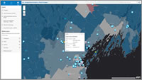
Image - Esri technology-based map application gives
first responders and others instant access to weather
warnings, utility data, population information, and social
media posts to drive faster, more collaborative power
resiliency during extreme events.
The solution providers built a common information model (CIM). The CIM acts as one source of the truth, ensuring all stakeholders have the same information regarding the location and the number of outages. Esri and EPRI demonstrated their initial results at this month's DistribuTECH, the world's largest annual event for electric power transmission and distribution.
"Communicating outage information, especially through the ability to view that data on a map, has traditionally been difficult for power companies due to varying formats of data and, frankly, timeliness of the data," Esri director of utility solutions Bill Meehan said. "I'm thrilled we could demonstrate that, regardless of how outage data is created, we can consume that data from any number of utilities and display it all together in a simple, easy-to-use Esri map."
Esri's mapping application pulls real-time outage information from countless utilities and publishes it as a feature service capable of being consumed at extremely large scales via the web. The map can mash up data layers from live weather, demographics, and social media feeds.
"Emergency personnel, media, and regulators can get accurate, real-time estimates of what's happening," Meehan said. "The data is quickly merged from many utilities and then summarized, analyzed, and visualized."
Utilities currently present outage information in map viewers. However, events like Hurricane Sandy point to the need for overlapping utilities to share this information via a common information model to facilitate collaboration among first responders, utilities, and customers during critical events. EPRI's work to develop the common information model framework, along with Esri's mapping application, allows this collaboration to take place.
OSTP announced its Outage Data Initiative (ODI) last year as a voluntary challenge for utilities, co-ops, municipalities, solutions engineers, vendors, and others, to collaborate on a data-driven solution to improve power restoration after storms and natural disasters. The ODI is in phase one, which involves the presentation of generalized outage data in a standard format (e.g., Esri's map viewer) for public consumption. Phase two involves more detailed outage data to be shared securely with first responders (e.g., police, fire, emergency medical services [EMS], American Red Cross).
Notable participants in the ODI include Duke Energy, BGE, ComEd, Google, iFactor Consulting, National Grid, PECO, SDG&E, and Southern California Edison.
Learn more about EPRI at
epri.com.
Learn more about Esri solutions for electric professionals at
esri.com/electric.
About Esri
Since 1969, Esri has been giving customers around the world the power to think and plan geographically. The market leader in GIS, Esri software is used in more than 350,000 organizations worldwide including each of the 200 largest cities in the United States, most national governments, more than two-thirds of Fortune 500 companies, and more than 7,000 colleges and universities. Esri applications, running on more than one million desktops and thousands of Web and enterprise servers, provide the backbone for the world's mapping and spatial analysis. Esri is the only vendor that provides complete technical solutions for desktop, mobile, server, and Internet platforms. Visit us at www.esri.com.
About EPRI
The Electric Power Research Institute, Inc., conducts research, development and demonstration (RD&D) relating to the generation, delivery and use of electricity for the benefit of the public. An independent, nonprofit organization, EPRI brings together scientists and engineers as well as experts from academia and the industry to help address challenges in electricity. EPRI's work spans nearly every area of electricity generation, delivery and use, management and environmental responsibility. They provide both short- and long-term solutions in these research areas for the electricity industry, its customers, and society. Learn more at epri.com.
Esri, the Esri globe logo, GIS by Esri, ArcGIS, www.esri.com, and @esri.com are trademarks, registered trademarks, or service marks of Esri in the United States, the European Community, or certain other jurisdictions. Other companies and products mentioned herein may be trademarks or registered trademarks of their respective trademark owners.
Images for Publication
http://www.esri.com/~/media/images/content/news/releases/15-1qtr/epri-sm.jpg
Esri technology-based map application gives first responders and others instant access to weather warnings, utility data, population information, and social media posts to drive faster, more collaborative power resiliency during extreme events.
Contacts:
Sarah Alban, Esri
Tel.: 909-793-2853, extension 1-6280
E-mail (press only):
Email Contact
General Information:
Email Contact