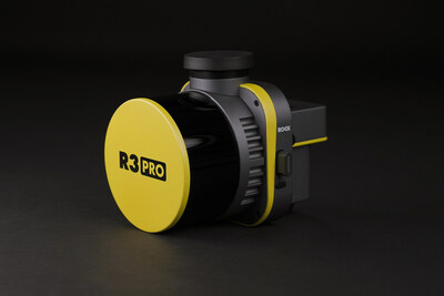
Inside the new ROCK R3, you'll find cutting-edge technology, including a geodetic-grade GNSS receiver and tactical-grade IMU. The R3 PRO comes equipped with a Hesai Pandar XT32 sensor, while the lower pricepoint R3 utilizes the Hesai Pandar XT16 sensor. The R3 includes a detachable 26MP camera for high-resolution RGB image capture. The sleekly designed R3 weighs only 1.26 kg (2.77 lb) compared to the previous ROCK 360 system's 1.70 kg (3.74 lb). In addition, the R3 offers optional advanced SLAM capabilities for mapping on the ground, as well as in areas with weak GNSS signals.
ROCK Robotic CEO Harrison Knoll is enthusiastic about offering the R3 to customers. "The ROCK R3 PRO is a major step forward for ROCK Robotic," Knoll stated. "It offers better accuracy, better SLAM, a better camera, a lighter payload — basically a better product all around. Not only will our current customers love it, but we're confident that the R3 will attract new customers who want a great hardware product along with our great software and support."
The R3 LiDAR system will integrate into ROCK Robotic's comprehensive LiDAR approach. "We want surveyors and mapping professionals to have the simplest workflow while getting the best results and deliverables," Knoll expressed. "From the time you're out in the field flying your drone to when you send deliverables to your client, ROCK makes it as easy as possible to make it happen. With the recently released ROCK Desktop software, R3 system and ROCK Cloud post-processing software, we've got all the bases covered. ROCK is definitely stepping up as a major player in the LiDAR arena."
For more information on the ROCK R3 and R3 PRO, visit www.rockr3pro.com.
About ROCK Robotic:
ROCK Robotic makes professional survey-grade LiDAR hardware and software for the 3D mapping industry. ROCK's unparalleled support team and pioneering technology help make LiDAR easier and more accessible for LiDAR and drone professionals.
![]() View original content to download multimedia:
https://www.prnewswire.com/news-releases/rock-robotic-introduces-r3-and-r3pro-lidar-advancing-survey-grade-commercial-mapping-systems-301801940.html
View original content to download multimedia:
https://www.prnewswire.com/news-releases/rock-robotic-introduces-r3-and-r3pro-lidar-advancing-survey-grade-commercial-mapping-systems-301801940.html
SOURCE ROCK Robotic
| Contact: |
| Company Name: ROCK Robotic
Vincent Aurand Email Contact 323-892-6622 |


