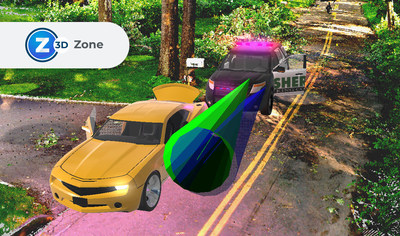
The announced release of FARO Zone 3D Software provides public safety professionals with a multi-modal, capture-device agnostic software program that can diagram, document, and analyze forensic scenes utilizing data from drones, 3D laser scanners, 2D photos and other traditional measurement devices, leaving no customer and no data collection method behind.
"This edition of FARO Zone 3D Software is the most versatile yet for data input and processing — making the most comprehensive scene documentation software on the market even better," said Noreen Charlton, Software Product Marketing Manager at FARO. "Public safety professionals can take images from almost any capture device — drones, photographs, laser scanners from a variety of manufacturers, hand-measured data and more — then model crime and crash scenes in 3D and virtually walk jurors through a forensic scene with an exceptional level of realism."
Aiding in achieving that realism, which is critical to solving and proving cases in the courtroom, Charlton points to a significant feature in this release of FARO Zone 3D software- improved point cloud capability. FARO Zone 3D software is available in two versions, Zone 3D Expert and Zone 3D Pro. With Zone 3D Expert, which incorporates a new proprietary photogrammetry engine, FotoPoints, users can convert photographs into point cloud data. This means, for the first time we are enabling users to take accurate measurements from 2D photos or 3D data. Also for the first time, users of 3D Pro can import point cloud data into the software for inclusion into forensic scene analysis.
These tools provide the functionality to accurately reconstruct any scene with multiple sources of data, to create factual diagrams, photo-realistic visuals, and give users the ability to create animations in a combined point cloud and panoramic image environment. Additionally, the camera lock feature allows a user to freeze a camera view to edit a drawing without changing the view. This can also be used to align an overlay image or video with a point cloud. Along with a large library of existing features, FARO Zone 3D software is the most comprehensive public safety tool for documentation, training, analysis and presentation.
FARO serves the AEC (Architecture, Engineering & Construction), O&M (Operations & Maintenance), 3D Metrology, and Public Safety Analytics markets. For over 40 years, FARO has been a pioneer in #RealityCapture, bridging the digital and physical worlds through data-driven reliable accuracy, precision, and immediacy, providing industry-leading technology solutions that enable customers to measure their world and use that data to make smarter decisions faster. For more information, visit www.faro.com.
![]() View original content to download multimedia:
https://www.prnewswire.com/news-releases/faro-zone-3d-forensic-scene-analysis-software-delivers-new-photogrammetry-capabilities-301671620.html
View original content to download multimedia:
https://www.prnewswire.com/news-releases/faro-zone-3d-forensic-scene-analysis-software-delivers-new-photogrammetry-capabilities-301671620.html
SOURCE FARO
| Contact: |
| Company Name: FARO
Jessica Hale Email Contact 407-333-9911 Financial data for FARO |


