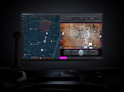
AUSTIN, Texas, Oct. 11, 2022 (GLOBE NEWSWIRE) -- DroneSense (www.dronesense.com), developers of the most trusted and reliable software platform for public safety drone operations, today announced the general availability of DroneSense Remote and Axon Air Remote powered by DroneSense. This breakthrough technology allows public safety agencies to remotely operate and deploy drones in emergencies, giving first responders a real-time view of what is happening before they arrive at the scene.
Many public safety agencies have drone programs where officers or firefighters operate a drone on scene while responding to an incident. Drone as a First Responder (DFR) programs go further, providing vital situational awareness on calls for service even before personnel arrives on scene. This approach protects both communities and public safety by giving agencies more time and information to determine the most appropriate response to a situation. The system retains detailed records of every flight, so that agencies can easily maintain transparency and accountability regarding their use of the technology within the communities they serve.
Agencies looking to start a DFR program now have everything they need for remote operations, thanks to DroneSense and Axon Air powered by DroneSense. DroneSense Remote and Axon Air Remote allow agencies to respond to any 911 call within seconds, with a single mouse click. The platform enables a teleoperator to remotely pilot drones from anywhere and aims to improve tactical decision-making and improve efficiency with fewer officer dispatches. Additionally, Axon Air Remote works seamlessly with Axon Evidence, Axon's digital evidence management system, and Axon Respond, Axon's real-time operations solution.
"We are excited to offer first responders the most advanced and comprehensive remote flying experience through DroneSense and Axon Air," said Chris Eyhorn, CEO of DroneSense. "DroneSense Remote is leading the industry with innovation and support for more drone models than any other platform, allowing agencies of all sizes and budgets to increase officer safety, improve incident response time, and achieve better outcomes."
With thousands of operational flights across leading agencies over the past few months, DroneSense Remote and Axon Air Remote have set a new bar for speed and precision in public safety remote drone operations and established an exciting new option for modern policing. The platform allows agencies to create fully-customizable flights to fit their needs, including flying DFR missions Beyond Visual Line of Sight (BVLOS) under an FAA waiver or remaining within Visual Line of Sight (VLOS) under an existing Certificate of Authorizations (COA) or Part 107 regulations. Built-in preflight checks, simple user interface, customizable geofences, continuous network integrity monitoring, and emergency landing sites create the industry's safest approach for demanding operational environments. DroneSense Remote and Axon Air Remote even adjust for elevated takeoff locations to ensure strict adherence to designated flight altitudes.
"DroneSense Remote is the platform that has enhanced our drone program," said Sgt. Daniel Anders with the San Antonio Police Department. "We now utilize drones to respond to calls for service much faster than we can with other assets."
DroneSense Remote is available for the DroneSense platform, and Axon Air Remote is available for the Axon Air powered by DroneSense platform. DroneSense and Axon Air Remote applications work with public safety's most popular drones, including the DJI Matrice 300, Mavic 2 Enterprise Dual and Zoom, and DJI's new Matrice 30 and Mavic 3 Enterprise series drones.
To learn more about DroneSense Remote, please visit www.dronesense.com/remote or for Axon Air Remote, please visit www.axon.com/products/axon-air.
Contact Information:
Ryan Bracken
Chief Product Officer
ryan@dronesense.com
512-582-0444
Related Images

Image 1: DroneSense Remote
DroneSense Remote view from the operator's station


