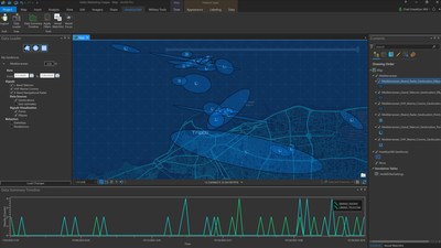
ArcGIS Pro add-in will help users easily ingest and visualize radio frequency data
HERNDON, Va., Feb. 4, 2021 — (PRNewswire) — HawkEye 360 Inc., the first commercial company to use formation-flying satellites to create a new class of radio frequency (RF) data and data analytics, today introduced the HawkEye RF Data Explorer, an add-in for Esri's leading geographic information system (GIS) ArcGIS Pro desktop software.
"HawkEye RF Data Explorer provides a powerful capability for our customers to integrate RF geospatial intelligence into fused, multi-intelligence analysis on the world's leading GIS platform," said Alex Fox, Executive Vice President, HawkEye 360. "By integrating the add-in into the ArcGIS ecosystem, analysts will significantly improve their ability to use and interpret RF data and analytics to enhance their understanding of global activity. This new dimension of information provides critical insights needed to effectively understand activity using a comprehensive set of intelligence sources."
HawkEye RF Data Explorer simplifies the experience of using the company's RF data and analytics by streamlining the process of ingesting, visualizing, and analyzing information. Users can manipulate RF data by area of interest, timeframe, and signal type to identify patterns of life and associated abnormalities necessary to proactively impact targeted outcomes.
The ArcGIS add-in integrates a variety of maritime geolocated RF signals and associated metadata to provide critical context on actors and activities. For example, users can view information related to a vessel's identity, activities (such as past sanctions violations) and voyage history. Vessels can be added to a watch list for automated monitoring.
"RF Data Explorer ingests HawkEye 360's data directly from cloud datastores into our flagship analysis product, ArcGIS Pro, offering unique and valuable insights to data analysts from a variety of subject areas, said Robert Laudati, Director, Global Partners and Alliances, Esri. "We look forward to building on this innovative partnership with HawkEye 360 and providing users with powerful and integrated tools."
HawkEye 360 is a leading commercial provider of space-based RF data and analytics. After successfully deploying a pioneering cluster of RF satellites in 2019, the company will commission six additional satellite clusters with enhanced data collection and processing capabilities in 2021 and 2022. On January 24, 2021, the first of these next-generation clusters, Cluster 2, was successfully launched and is undergoing testing to transition into operations. HawkEye 360's RF signal data and analytics delivers actionable insights and a unique layer of knowledge for national security operations, maritime domain awareness, environmental protection, and a wide range of additional applications.
Access HawkEye RF Data Explorer in the ArcGIS Marketplace or learn more by visiting, https://www.he360.com/products/rfdata-explorer/.
About HawkEye 360
HawkEye 360 is delivering a revolutionary source of global knowledge based on radio frequency (RF) geospatial intelligence to those working to make the world a safer place. The company operates the first-of-its-kind commercial satellite constellation to detect, characterize, and geolocate a broad range of RF signals. This unique RF data and analytics equip our global customers with high-impact insights needed to make decisions with confidence. HawkEye 360 is headquartered in Herndon, Virginia.
About Esri
Esri, the global market leader in geographic information system (GIS) software, location intelligence, and mapping, helps customers unlock the full potential of data to improve operational and business results. Founded in 1969 in Redlands, California, USA, Esri software is deployed in more than 350,000 organizations globally and in over 200,000 institutions in the Americas, Asia and the Pacific, Europe, Africa, and the Middle East, including Fortune 500 companies, government agencies, nonprofits, and universities. Esri has regional offices, international distributors, and partners providing local support in over 100 countries on six continents. With its pioneering commitment to geospatial information technology, Esri engineers the most innovative solutions for digital transformation, the Internet of Things (IoT), and advanced analytics. Visit us at
esri.com.
![]() View original content to download multimedia:
http://www.prnewswire.com/news-releases/hawkeye-360-introduces-hawkeye-rf-data-explorer-for-esri-arcgis-to-improve-the-accessibility-of-radio-frequency-intelligence-301222247.html
View original content to download multimedia:
http://www.prnewswire.com/news-releases/hawkeye-360-introduces-hawkeye-rf-data-explorer-for-esri-arcgis-to-improve-the-accessibility-of-radio-frequency-intelligence-301222247.html
SOURCE HawkEye 360
| Contact: |
| Company Name: HawkEye 360, Esri
Media Contact for HawkEye 360, Alexandra Phelps Email Contact 703-966-0831 |


