Velodyne Lidar Sensors Power GeoSLAM’s Data Capture Solutions
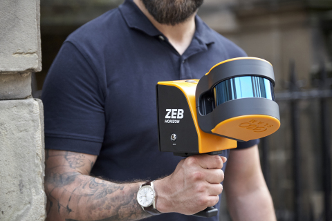
SAN JOSE, Calif. — (BUSINESS WIRE) — May 7, 2020 — Velodyne Lidar, Inc. today announced a multi-year sales agreement with GeoSLAM, a global market leader in 3D geospatial technology solutions. GeoSLAM uses Velodyne lidar sensors in its ZEB-HORIZON mobile scanner that provides 3D mapping of indoor, underground and difficult to access environments without the need for GPS.
This press release features multimedia. View the full release here: https://www.businesswire.com/news/home/20200507005153/en/

GeoSLAM uses Velodyne’s Puck LITE™ sensor in its ZEB-HORIZON mobile scanner that provides 3D mapping of indoor, underground and difficult to access environments without the need for GPS. (Photo: GeoSLAM)
Velodyne’s Puck LITE™ sensors enable GeoSLAM systems to achieve data capture of intricate measurements from up to 100 meters away, delivering rapid results that can save time and money. ZEB-HORIZON addresses a wide variety of solutions, including building information modeling (BIM), construction, real estate, surveying and mining. In an innovative application, Virginia Tech researchers are bringing a World War I battlefield to classrooms and museums with ZEB-HORIZON mapping as part of a virtual reality experience. GeoSLAM scanners are also being deployed by Entropy Group to map K-12 schools in the United States to provide first responders with detailed floor plans in emergency situations.
“Working with Velodyne has opened up new possibilities for collecting geospatial data, allowing companies to capture, process and understand the world around them,” said Darren Burford, Chief Revenue Officer, GeoSLAM. “We combined Velodyne sensors with our robust SLAM algorithm to create an easy-to-use mobile product that can generate 3D point clouds in real time.”
“GeoSLAM is helping companies transform their businesses with go-anywhere 3D mapping solutions that enable fast data collection in a variety of environments,” said Erich Smidt, Executive Director Europe, Velodyne Lidar. “Their solutions demonstrate how Velodyne sensors can help decision makers create digital twins – digital replicas of physical structures and other areas of interest – that have great accuracy and detail.”
Velodyne Puck LITE sensors deliver a high-resolution image to measure and analyze indoor, outdoor and underground environments. Designed for applications that require a sensor with a low weight and compact size, the Puck LITE delivers outstanding resolution and performance for UAV/drone, handheld and vehicle applications. It provides a full 360-degree environmental view to deliver real-time 3D data.
About Velodyne Lidar
Velodyne provides smart, powerful lidar solutions for autonomy and driver assistance. Headquartered in San Jose, Calif., Velodyne is known worldwide for its portfolio of breakthrough lidar sensor technologies. Velodyne’s founder, David Hall, invented real-time surround view lidar systems in 2005 as part of Velodyne Acoustics. Mr. Hall’s invention revolutionized perception and autonomy for automotive, new mobility, mapping, robotics, and security. Velodyne’s high-performance product line includes a broad range of sensing solutions, including the cost-effective Puck™, the versatile Ultra Puck™, the autonomy-advancing Alpha Prime™, the ADAS-optimized Velarray™, and the groundbreaking software for driver assistance, Vella™.
About GeoSLAM ( www.geoslam.com)
Headquartered in the UK, GeoSLAM is a global market leader in “go-anywhere” 3D mobile mapping technology. Its unique handheld technology is highly versatile and adaptable to all environments – especially spaces that are indoor, underground or difficult to access, providing accurate 3D mapping without the need for GPS. GeoSLAM technology is easy to use and within minutes customers can build a highly accurate 3D model of their environment. The company was founded in 2012 as a joint venture between CSIRO (Australia’s National Science Agency) and 3D Laser Mapping. Serving the surveying, engineering, mining, forestry, facilities and asset management sectors, GeoSLAM has an expanding global network of over 70 distributors – including over 15 in U.S. locations – https://geoslam.com/contact/.
View source version on businesswire.com: https://www.businesswire.com/news/home/20200507005153/en/
Contact:
Media Contact
Landis Communications Inc.
Sean Dowdall
(415) 286-7121
velodyne@landispr.com


