Newly captured aerial maps show before and after images to support cleanup efforts by public safety organizations, utility companies and insurance agencies
SOUTH JORDAN, Utah — (BUSINESS WIRE) — September 24, 2018 — Nearmap, a premium global location content provider specializing in high-resolution, aerial maps, has flown and captured areas in North and South Carolina impacted by Hurricane Florence. This imagery is already supporting the extensive cleanup and reconstruction efforts across the wide ecosystem of public safety, utility companies, insurance agencies, and numerous contractors in many industries.
This press release features multimedia. View the full release here: https://www.businesswire.com/news/home/20180924005648/en/

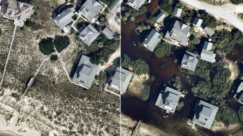
High-resolution aerial imagery from Nearmap of Southport, N.C., shows conditions in a neighborhood before and after Hurricane Florence. (Photo: Business Wire)
High-resolution captures from the Wilmington and Myrtle Beach areas are now online and available for immediate use with more areas scheduled to come online over the next several days. The post-hurricane coverage includes about 4,530 square kilometers around the coastline from Newport, N.C., to Myrtle Beach, S.C., covering a population of about 752,000 people.
Before the hurricane, Nearmap had already covered more than 30,000 square kilometers in North and South Carolina with ortho imagery and more than 12,000 square kilometers with oblique imagery. With previous aerial maps taken at least once a year totaling over 140,000 square kilometers online, some of them dating back to 2014, users are able to compare current imagery with historical photos.
“A key element to the recovery efforts is having access not only to high-resolution imagery from after the storm, but also to historical aerial captures from before the storm hit,” said Rob Newman, CEO and managing director of Nearmap. “Historical captures provide consistency and contrast, enabling crews to look at the current truth on the ground and compare it to previous time periods to help assess the damage along the coastlines.”
All pre- and post-hurricane imagery can be accessed through a standard web browser using Nearmap’s intuitive MapBrowser™, through Nearmap partners, or via APIs to integrate with common GIS, CAD and other applications.
All the Nearmap pre- and post-hurricane imagery is published at sub-3” Ground Sampling Distance (GSD), which allows users to see great detail on the ground. At this resolution, they can clearly identify important ground conditions such as roof blow-off, property damage and flooding. The same is true for streets and all other ground features, providing details for users to complete analysis both pre and post storms.
“Our thoughts are with the residents of North and South Carolina recently impacted by the hurricane,” said Newman. “We are pleased that Nearmap customers are using our imagery to help restore these neighborhoods, and help residents fix and rebuild after rooftop, flooding and other damage.”
Nearmap customers use aerial imagery to assist in the following aspects of post-disaster cleanup:
- Public Safety: Access to immediate, crystal-clear aerial imagery of areas affected by storm damage for emergency response routing and safety.
- Utilities: View all areas where above-ground utilities have been affected and also see where infrastructure is down or damaged and causing hazards.
- Reconstruction Efforts: Compare historical image captures with post-event imagery to see structure elements and provide proper measurements to rebuild.
- Insurance: View impacted properties to see first-hand damage and potential structural damage.
To see some of the images captured, including historical comparisons in the Hurricane Florence area, visit https://go.nearmap.com/hurricane-florence-aerial-image-gallery.
About Nearmap
Nearmap brings the real world to you. We capture, manage and deliver the most current location content in the world, allowing businesses and governments to explore their environment easily. With Nearmap, organizations unlock opportunities that consistently inform decision-making and profoundly transform the way they work. Our high-resolution, frequently updated aerial imagery is 3-inch GSD, better than satellite imagery. Delivered within days of capture, Nearmap shows changes over time. Users save time and money, reduce site visits, and efficiently plan with current, clear imagery.
Nearmap is delivered through a refreshingly easy-to-use interface called MapBrowser™ or accessed via Esri® and Autodesk products.
View a current project in Nearmap today. For more information, visit http://go.nearmap.com.
View source version on businesswire.com: https://www.businesswire.com/news/home/20180924005648/en/
Contact:
PR Contact:
SnappConner PR
Mark Fredrickson, 801-806-0161
Email Contact


