U.S. Geological Survey Adds TIGER Roads as Basis for National Map
WASHINGTON, Nov. 19, 2014 — (PRNewswire) — The convenience of getting directions today on smartphones and tablets can trace its roots to the digital geographic database created 25 years ago by the U.S. Census Bureau.
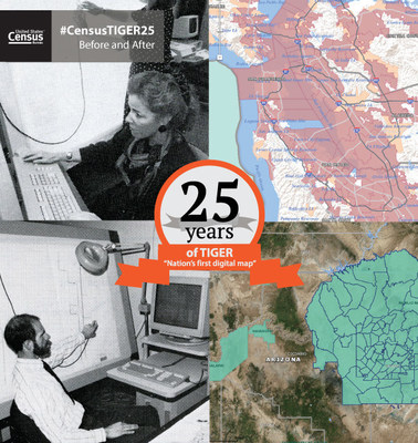
The Topologically Integrated Geographic Encoding and Referencing (TIGER) database — the first nationwide digital map of roads, boundaries and water — was initially created for the 1990 Census to modernize the once-a-decade head count. However, its impact has extended well beyond its initial purpose by offering common map data in electronic form that powers today's geographic information system industry.
In addition to celebrating this 25-year milestone, the Census Bureau is also announcing that the U.S. Geological Survey will use TIGER as the primary roads layer on The National Map Viewer and US Topo map product starting in 2015. The TIGER roads layer, which consists of all roads in the U.S., joins the TIGER governmental unit boundaries layer as an authoritative source of current, accurate and high-quality geospatial data for The National Map, which delivers topographic information for the nation. The National Map has many uses, ranging from recreation to scientific analysis to emergency response.
"The Census Bureau's history is one of innovation," Census Bureau Director John H. Thompson said. "From the Hollerith tabulating machine to the use of UNIVAC I, one of the first computers, and the development of TIGER, these achievements have provided significant technological advancement and improved our ability to deliver timely, reliable statistics. TIGER provides the nation with a valuable set of geographic information for use by all, including businesses and all levels of government."
As a national digital map database, TIGER contains all geographic features — such as roads, railroads, rivers, and legal and statistical geographic boundaries — needed to support the Census Bureau's data collection and dissemination programs. The TIGER/Line Shapefiles are updated annually and available for free download via census.gov.
"TIGER is just one example of how innovation in the government has spurred innovation and positive economic results in the private sector," U.S. Secretary of Commerce Penny Pritzker said. "TIGER helped grow an entire industry — the GIS industry — and created many good jobs by providing popular mapping products integral to the everyday lives of Americans."
TIGER Creation
The development and completion of the first nationwide digital map of the United States and Puerto Rico took nearly 10 years.
Prior to TIGER, geographers created paper maps for enumerators to use in census operations. Census Bureau geographers and cartographers manually added census boundaries to existing maps gathered from a variety of sources. Copies of these maps were then made available to enumerators.
These paper maps varied in quality and scale and were quickly outdated, particularly when boundaries changed. Thus, TIGER was created to provide a single source of geographic data.
"TIGER came into existence with no backup plan or room for failure," said Tim Trainor, who worked on the project 25 years ago as a cartographer and is now chief of the Census Bureau's Geography Division. "We knew there was a need to produce high-quality maps from a consistent source, and that drove the development of TIGER."
To create TIGER, the Census Bureau collaborated with the U.S. Geological Survey. USGS created a special topographic map series for roads and rivers using new scanning technology that automatically digitized roads and rivers into separate files. The Census Bureau and USGS geographers manually digitized printed maps by recording individual roads, boundaries, rivers, railroads, etc., onto the computer. Once each road and water file was created for a given area, the files were merged to create one integrated map.
TIGER and the Census Bureau Today
Today, every state and local government has the capability to create its own geographic information system with small-area census geographic data using publicly available extracts of the TIGER database.
Over the past 25 years, the Census Bureau has continued to innovate and evolve with changing technology. In addition to creating TIGER, the Census Bureau was one of the first government agencies to create a public website and has since created interactive maps and Web-mapping services available both online and on mobile devices. These innovations make Census Bureau statistics easier to access than ever before.
The new partnership with the USGS and the Census Bureau will return more consistent and high-quality geographic data back to local communities. Using TIGER as the public domain geospatial data source alleviates the data dissemination constraints and costs of using commercial data.
"The USGS is pleased to use the TIGER database as a base layer of The National Map and US Topo quadrangles," said Julia Fields, deputy director of the USGS National Geospatial Program. "TIGER provides The National Map with an accurate, public domain database that meets the needs of our user community. Our partnership represents good government by coordinating resources, eliminating procurement costs and developing improved data that are freely available to American citizens and businesses."
The Census Bureau offers several file types and an online mapping application of TIGER. Products include:
- TIGERweb
- TIGER/Line Shapefiles - New 2014 Shapefiles
- TIGER/Line Geodatabases
- TIGER/Line with Selected Demographic and Economic Data
- Cartographic Boundary Shapefiles
- KML - Cartographic Boundary Files
TIGER Tomorrow
The Census Bureau improves TIGER each year, and planning for the 2020 Census is bringing new enhancements. By engaging with both the private and public sector to enhance geographic programs, supporting research to improve geospatial products and contributing to GIS conferences, the Census Bureau continues to embrace changing technologies and techniques and strives to make greater amounts of its data available to all.
Virginia Hyer
Public Information Office
301-763-3030
Email Contact
CB14-208
Story Map
Graphic |
JPG |
PDF |

Photo -
http://photos.prnewswire.com/prnh/20141119/159715
Logo -
http://photos.prnewswire.com/prnh/20110428/DC91889LOGO
SOURCE U.S. Census Bureau
| Contact: |
| U.S. Census Bureau
Web: http://www.census.gov |


