Welcome to GISWeekly!
GISWeekly examines select top news each week, picks out worthwhile reading from around the web, and special interest items you might not find elsewhere. This issue will feature Industry News, Top News of the Week, Acquisitions/Agreements/Alliances, Announcements, People, New Products and Events Calendar.
GISWeekly welcomes letters and feedback from readers, so let us know what you think. Send your comments to me at giscafe-editor@IBSystems.com
Best wishes,
Susan Smith, Managing Editor
Industry News
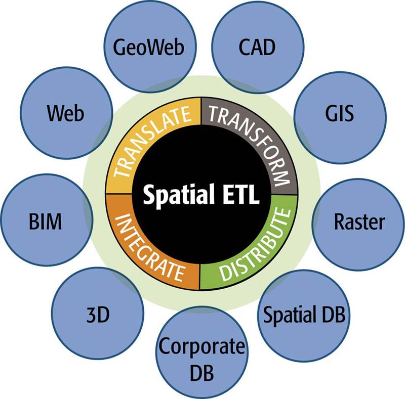
The Many Formats of FME
By Susan Smith
One thing about the Safe Software guys – they never let you forget they’re Canadian, and are always happy to point out if someone else is, too.
 [
Click to Enlarge ] [
Click to Enlarge ]
|
For Intergraph users who need to access spatial data in a variety of formats, translate and transform it into a Geo-Media or G/Technology friendly data model and format, to share out the resulting dataset(s) with users inside and outside their organization, Safe offers a customized spatial ETL solution. The FME Intergraph Edition offers support for the common formats Intergraph users work with, such as AutoCAD, ESRI ArcSDE, Oracle Spatial or GeoRaster, Microsoft SQL Server or Access, and others.
Lutz’s talk revolved around case studies where customers used G/Technology or Geomedia. In a similar vein, he spoke about how Safe is helping organizations involved in the INSPIRE spatial data infrastructure (SDI) initiative overcome two critical challenges: semantic translation and data sharing.
In two case studies presented, people brought data in or out of Geomedia to share across agencies. In one example, the Alabama Department of Revenue, the department needed to accomplish a typical CAD to GIS migration in the most efficient way with the least manual effort.
 [
Click to Enlarge ] [
Click to Enlarge ]
|
In another case study, the company brought data from an MGE-like system that was more of a CAD/GIS hybrid together in Geomedia, while doing quality assurance along the way. “They made sure that if they formed polygons, that there weren’t more than two interior points in each polygon. Or if some of the polygons wouldn’t close, they could send that back to the legacy system to get fixed.”
According to Lutz, Geomedia’s reputation for being able to integrate and access data from various sources is well respected in the industry. Geomedia’s reach can be extended further, however, by adding FME technology into the Geomedia framework.
“Intergraph made several variants of MGE that went by different names, so in this particular case it was called ISFC, a hardware/software combination which is still being used in some areas of the federal government in the U.S.,” Lutz explained. “Fortunately, for Safe and for FME, the data model underneath was identical to MGE’s so they were just able to use our stuff out of the box.”
Further, they used FME to effectively move data models --not actual data – but data models between the ESRI world and the Geomedia world. “In particular, the big benefit they got there was that in the ESRI world someone had gone to the effort of defining what they called ‘coded domains.’ In other words, for a particular column, the value it can have are these eight choices, in other words, a pick list, which could be a number of lanes, pavement types, etc.. There were a great number of domains that had a set number of values to be set up on the Geomedia side, and they were able to use FME and Spatial ETL technology to migrate the actual data model across. The customer said it saved them dozens of hours of very tedious manual effort rekeying this data. Lutz said this was not the usual customer they deal with. “Normally we move data around, and to a smaller degree, data models, but here we were flat out moving data models around.”
In Belgium, FME and Spatial ETL were used to facilitate greater flexibility in the tools they wanted to use in the development of the National Geographic Institute (NGI) of Belgium's SDI. By bringing data into their GeoMedia environment, they were able to share up-to-date geographic information with other government agencies involved in the European INSPIRE initiative. Lutz demonstrated how customers are using FME to bring data from multiple formats, including MicroStation, ESRI SDE and AutoCAD, into the GeoMedia environment and share it with others both inside and outside their organization.
The company used a non-Intergraph database as their central database which they planned to use as a source for their Spatial Data Infrastructure (SDI) publishing. However, they wanted to use some Intergraph technologies in the back to do all the data preparation and data Quality Assurance. They used Safe Software staff to create the pathways, and they felt it let them use the optimal tools they could for each job. Without FME they said they would have had to choose another stereoplotting configuration and lose the possibility of validation or choose another central database format (SDO) and another field completion software. “They couldn’t have done what they felt was optimal for SDI initiatives, and this is a real need for them,” said Lutz.
“These SDI initiatives force people to make tough decisions about how they want to publish their data,” said Lutz. “The really interesting aspect of it is, what are the ripple effects of that decision and how insulated is the rest of your workflow from that decision? The message we would have is if you use our products you can be very insulated, you can make one decision as to how you’re going to publish your stuff for an SDI and not turn the world upside down for your whole production chain in-house. It’s all to do with the European INSPIRE initiative. In North American there is a national SDI initiative that a lot of government organizations at all levels are looking to implement across the board.”
 [
Click to Enlarge ] [
Click to Enlarge ]
|
Interestingly, none of these employees were programmers nor computer scientists. The water agency only hired engineers, who were all self trained in their various tasks. They managed to pull off this complex data modeling without writing a line of programming code.
Lutz said that Safe has been working for so many years with legacy systems such as FRAMME and MGE that as a result, their support is very attuned to those systems. FME attempts to support every system they can.
In the case of Fingal County, they have a very well modeled source system, even though it is legacy, according to Lutz. “It’s working fine for them, they don’t want to replace it, and now they’re able to leverage that stability and years of information and still publish it on the web in a very efficient way.”
In the coming months, Lutz said to watch for their new FME Server which will play a significant role in innovative ways of sharing data.
INSPIRE
Munich University of Technology (TUM) and the University of Zurich (ETH) are working with con terra, Safe Software’s partner in Germany, who is involved with the INSPIRE specification process for metadata and network services. Used at the universities are Safe Software’s spatial ETL solution FME in their research to find a generic way for the Cadastral Agencies of Germany and Switzerland to harmonize their spatial data, while taking into account the specifications of the INSPIRE initiative.
“A key part of the INSPIRE project is to provide data in data models that are well understood by end users, and the challenges that the providers of the data may not want to have their data modeled in that way. So once the research that has been going on has been to take the data from how it’s available and then transform it as it’s being accessed into the data model that’s being requested. It’s really dynamic, or on the fly data transformation.”
“One of the big needs coming out of INSPIRE discussions is the need for metadata support,” Lutz pointed out. “The INSPIRE initiative is being mandated for these organizations to include metadata support. It is one of our core areas of focus for our next release. We’re really going to be stepping up our development efforts, and are excited about being able to offer that soon.”
Top News of the Week
Infoterra Ltd, a leader in the provision of geospatial products and services, is pleased to announce the first of a new series of GeoImaging User Group Conferences. The 2008 residential conference will run from 29th to 30th September at St. Anne’s College, Oxford University. For more information or to register for this event please email the conference organizer Email Contact.
Pratt & Whitney Rocketdyne helped scientists better understand global warming and hurricane prediction by successfully boosting the 1,100-pound Jason 2 satellite into orbit from Vandenberg Air Force Base . Jason 2 is onboard a United Launch Alliance Delta II rocket powered by Pratt & Whitney Rocketdyne's RS-27A engine. It was the 223rd consecutive successful mission for a launch vehicle powered by the RS-27 family of engines. Pratt & Whitney Rocketdyne is a United Technologies Corp. company.
Acquisitions/Agreements/Alliances
1Spatial announced the acquisition of ComSine, a privately owned SME specializing in IT consultancy and development for the telecommunications, navigation and geographic information industries, including satellite Earth observation.
Announcements
Research and Markets has announced the addition of the "Geographic Information System Market 2007-2010" report to their offering.
The market for GIS applications is witnessing demand for route planning and reducing costs related to delay in transit. Further, GIS also helps companies to plan the most efficient route for movement of goods - covering several nodes and routes. In addition, organizations have begun to use discrete event simulation in congestion management and transport incident management, driving the demand for GIS.
The report forecasts the market size of GIS applications over the period 2007-2010. Further, the total market is segmented into various geographic regions and verticals. The report also presents markets size for major countries in various regions. In addition, the report identifies major selling drivers for the GIS application for the major verticals.
NAVTEQ, a global provider of digital map data for location-based solutions and vehicle navigation, announced yesterday during an awards ceremony at CommunicAsia 2008 that Joikusoft is the Grand Prize Winner of this year's NAVTEQ Global LBS Challenge -- Asia-Pacific (APAC).
As the Grand Prize Winner, Joikusoft received a prize package valued at $275,000 USD, including $50,000 USD in cash and $225,000 USD in NAVTEQ data licenses. Joikusoft's solution, JoikuSpot, is a free location-aware mobile software solution that turns Nokia Smartphones into hotspots. When JoikuSpot software is installed on the phone, laptops and internet tablets, it can establish wireless internet connections via the phone's 3G internet connection. Virtually any wireless device can become its own hotspot. Three runners-up were also announced: First Runner-up, Road-Guard; Second Runner-up, Point-I; and Third Runner-up, Pacific DataVision. Each runner-up received $7,500 USD in cash along with data licenses valued at $150,000 USD.
1Spatial announced their participation in the European Commission’s INSPIRE Conference in Maribor, Slovenia from 23rd - 25th June 2008.
The INSPIRE Conference, formerly the EC-GIS Conference, organized by the European Commission’s Joint Research Centre (JRC) provides a forum for sharing information and experiences related to the implementation of INSPIRE and the development of Spatial Data Infrastructures (SDIs) in general. INSPIRE Drafting Teams and Thematic Working Groups will be given the opportunity to report on the development of the INSPIRE Implementing Rules and attendees will be able to further their understanding of the challenges of implementation, such as costs and coordination across different levels of governance. The conference will also identify key issues and opportunities for European SDI projects.
The Association for Geographic Information (AGI) has announced the full conference programme for their 2008 Annual Conference. The theme of AGI GeoCommunity ’08, ‘Shaping a Changing World’, is designed to address topical issues, such as such as climate change, globalization, neogeography, mobile technology, 3D visualizations, legislative and policy drivers, business models and ROI, all of which are grounded in or central to the use of geographic information. A packed conference programme will kick off with keynote presentations from Sean Phelan, Founder of Multimap, Vanessa Lawrence, Director General of the Ordnance Survey, Charlie Pattinson of the Environment Agency and Charles Kennelly of ESRI (UK).
ESRI's 2008/2013 demographic data updates identify new trends such as the potential retirement of the baby boomers, reduced consumer spending, changes in income, and rising unemployment rates. Updated data variables, such as population, housing, age, income, and home value, ensure that analysts can conduct their research with the most accurate information, particularly for fast-developing areas.
Additions and changes in the 2008/2013 demographic data include new tables for the 2008 Population 25+ by Educational Attainment and the 2008 Population 15+ by Marital Status variables, extension of the 2008 Household Net Worth table to $1 million, and expansion of the 2008 Household Net Worth by Age of Householder table to $500,000.
James W. Sewall Company announced the formation of Geospatial Solutions (GS), a new GIS-oriented technology group that will develop and deliver innovative products and services to Sewall clients in government and industry. To lead the GS team and bring to market new offerings, Sewall has hired technology executive David Levine as Vice President, and GIS product development professional Bill Sharp as Product Manager.
People
ESRI Canada is pleased to announce that retired Lieutenant-Colonel Pierre Bilodeau has recently joined ESRI Canada as the Public Safety Industry Manager. Lt. Col. Bilodeau will work with the public safety user community by providing existing and new public safety customers with unique insight into how they can leverage GIS technology to improve their operations.
Dr. Michael Phoenix, who dedicated his career at ESRI to educating people about and evangelizing for geospatial science and technology, will be presented next week with the 2008 University Consortium for Geographic Information Science (UCGIS) Educator Award.
New Products
ERDAS announced the release of an ECW and JPEG 2000 plug-in for AutoCAD 2007 / 2008 / 2009. AutoCAD users can now access massive amounts of geospatial image data (100’s of gigabytes or terabytes) through the ECWP high-performance streaming imagery protocol.
The ECWP streaming protocol is provided by ERDAS’ Image Web Server (IWS). ECWP transmits JPEG 2000 or ECW data. JPEG 2000 is the non-proprietary standard image format for the International Organization of Standardization (ISO), supported by most major geospatial applications. ECW is an image compression format developed by ERDAS with major industry support.
Blue Marble Geographics announced the release of their online, searchable knowledge base. Blue Marble’s geospatial data manipulation and conversion solutions are used worldwide by thousands of GIS analysts at software companies, universities, oil and gas companies, civil engineering, surveying, technology, enterprise GIS groups, government and military organizations.
Pitney Bowes MapInfo, the leading global provider of location intelligence solutions, introduced the Location Intelligence Component (LIC) for IBM Cognos 8 business intelligence software. Customers in all industries, including retailer Camping World and public entity MassHousing, the Massachusetts Housing Finance Agency, can now incorporate location analysis into their IBM Cognos 8 BI applications to more efficiently monitor and analyze their enterprise data.
CARIS is pleased to announce the release of version 4.3 of its web mapping software, Spatial Fusion Enterprise, featuring real-time target tracking.
Spatial Fusion Enterprise is a web mapping engine for the integration of existing data from many sources, formats and locations and introduces geospatial visualization and analysis tools to support strategic short and long-term decision making without unnecessarily impacting your current operational processes.
The Appalachian Mountain Club (AMC) is offering a new web-based trail mapping application created by Applied Geographics, Inc. (AppGeo). The application, known as the White Mountain Guide Online was launched to coincide with the 100th anniversary of the printed White Mountain Guide (WMG) in September 2007 and now has nearly 2,000 subscribers.
Upcoming Events
| 21st ISPRS Congress --Silk road for Information from Imagery | |
| Date: | July 3 - 11, 2008 |
| Place: | Beijing International Convention Center (BICC)
Asian Games Village , Beijing, China |
| The Silk Road is the most famous East-West trading route in ancient times. It served not only as the conduit for goods but also as the highway for knowledge transmission between the east and the west. Nowadays, the need for timely, high-quality, long-term, global spatial information is increasing rapidly.
|
|
| 2008 IEEE International Geoscience & Remote Sensing Symposium | |
| Date: | July 6 - 11, 2008 |
| Place: | Boston, MA USA |
| Welcome to the official website for the 2008 IEEE Geoscience and Remote Sensing Symposium to be held in Boston! IGARSS’08 will be the 28th annual symposium for GRSS and will continue the excellent tradition of gathering world-class scientists, engineers and educators engaged in the fields of geoscience and remote sensing to meet and present their latest activities.
|
|
| GEOBrasil Summit 2008 | |
| Date: | July 15 - 17, 2008 |
| Place: | Imigrantes Convention Hall
São Paulo , Brazil |
| GEOBrasil Summit 2008 presents new trends, products and services earmarked for integrated solutions connected with mapping, localisation, navigation, geographic localisation and analysis for management of public and private companies. Integrated events: GEOBrasil, GNSS Navis, GEO Oil & Gas and GEOCities.
|
|
| Spatially Enabled Government 2008 | |
| Date: | July 21 - 24, 2008 |
| Place: | Rydges Lakeside Canberra
Canberra, ACT 2601 Australia |
|
SEGS ’08 will focus on Maximising the Value of Geospatial Data in Government to Enhance Service Delivery and Evidence Based Policy Learn Strategies to Overcome the Challenges of: 1 Expanding interoperability between government departments
|
|
| GeoWeb 2008 | |
| Date: | July 21 - 25, 2008 |
| Place: | Vancouver
Canada |
| The theme for the GeoWeb 2008 conference is Infrastructure: Local to Global. This implies the GeoWeb has a local or community dimension as well as a global one – that the integration of local infrastructures will give rise to a global infrastructure – that global aggregators will drive the creation of local infrastructures.
|
|
| Sanborn LIDAR seminar series | |
| Date: | July 22, 2008 |
| Place: | Hilton Garden Inn--Tyson's Corner
8301 Boone Blvd., Vienna, VA 22182 USA |
| Please be our guest! Sanborn would like to invite you to our first annual LiDAR Seminar Series–featuring a brief introduction into the basics of LiDAR, it's latest technological developments, and a comprehensive overview on application trends. We will also be hosting a live software demo for customizable 3D and cross section viewing.
We are very excited and are confident your attendance will bring you nothing less than a valuable, informative experience. There is no charge to attend this event and a continental breakfast will be included. I would like to announce the location and time for the last two seminar events. The seminar in Albany NY will take place on August the 14th from 8-11 AM
|
|