


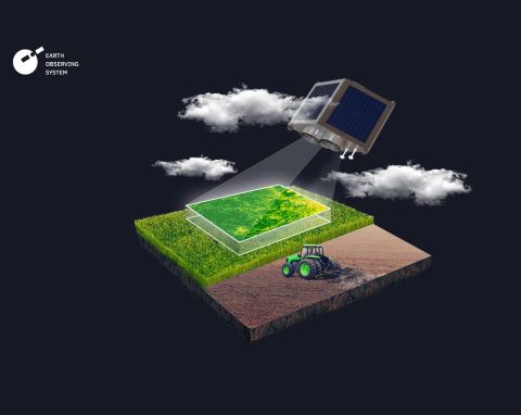
Satellite imagery and geospatial data have been actively used in agriculture due to the development of technology over the past few decades. The information obtained with these technologies is used for numerous purposes, including land cover analysis, NDVI calculation and visualization of field data on a map. Based on GIS, the concept of precision farming has also been developed, the tools enabling farmers to make effective decisions based on data and reduce the negative environmental impact. With the help of satellite data processing, it is now possible to view things that are not visible to the naked eye, such as the energy emitted by plants. By calculating the
most common vegetation index, it becomes possible to estimate the density and greenness of vegetation. In this article, you will learn about various geospatial data applications in agriculture and the application of satellite image analytics software for agriculture created by EOS Data Analytics.
Crop Yield Prediction
Accurate crop forecasting using AI and satellite data makes it possible to maintain food security. In addition, enterprises use this opportunity for budget planning and profit forecasting. Crop productivity is determined using convolutional neural network algorithms. The accuracy of determination by algorithms trained based on images of various crops, the yield of which is already known, is more than 80%. EOS Data Analytics offers superior accuracy in satellite data analytics for various industries and provides effective agricultural technological solutions. EOSDA scientists and engineers have developed efficient yield estimation methods using remote sensing and machine learning models. With the help of Earth observation data, EOSDA creates solutions that cover areas of all sizes, from individual farms to entire regions. Depending on the quality of statistical data, the accuracy of yield estimates can reach up to 95%.
Insect and Pest Control
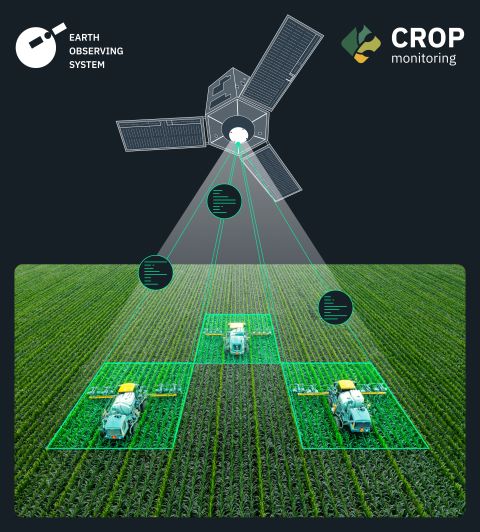
The crop protection industry constantly evolves and has many tools, methods and strategies. It gives farmers more and more options to manage pests, weeds and diseases effectively. Weeds compete with plants for water and nutrients. In addition, weeds grow aggressively, occupy the space intended for crops, and suppress young plants. EOS Data Analytics has developed the EOSDA Crop Monitoring precision farming platform, thanks to which it is possible to provide yields with the proper protection. This tool enables farmers to detect threats and send scouts for analysis on time. Users can use the feature to detect abnormal NDVI values and apply appropriate preventive and control measures. Protecting plants from diseases is difficult, as it depends on various factors such as plant age, weather, and environmental conditions. Identifying the disease, particularly in its early stages, can be challenging, so analysing the symptoms is critical. Techniques to protect crops from diseases include using chemicals, cultivating disease-resistant species, regular monitoring, crop rotation, and so on. Regular satellite monitoring helps to detect factors that cause infections. Thanks to the EOSDA Crop Monitoring platform, farmers can access up-to-date weather forecasts and historical data. It helps to analyse temperature fluctuations and protect plants from potential thermal stress, for example, by creating a drain to drain moisture during heavy rains. Pest control can be effectively carried out by methods of biological control, crop rotation and In this case, applying a set of measures, including monitoring and damage prevention, is most effective.
Irrigation Control
Precise watering saves water significantly and plans activities based on plants' needs. Accurate irrigation planning requires reliable information about the field's current state and the precipitation forecast. In addition to the ability to calculate NDVI, EOSDA Crop Monitoring is also available for NDMI calculation on the platform. The Normalized Difference Moisture Index helps identify moisture deficits and prevent crop loss. This index allows you to identify under-irrigated areas, making saving resources possible by irrigating only those plants that lack moisture.
Flooding, Erosion, and Drought Control
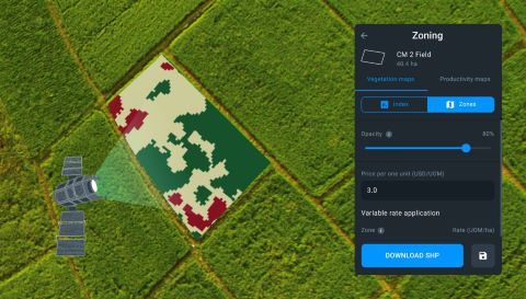
Remote sensing tools are excellent for monitoring soil health in extensive agricultural lands and for small farmers. EOSDA Crop Monitoring is an example of a satellite-driven for soil erosion control. The Zoning feature in EOSDA Crop Monitoring helps determine the required amount of mineral and organic fertilizers for different plots, depending on their needs. Farmers can divide their fields into multiple zones using this feature based on vegetation indices, including the NDVI formula. Each zone on the map shows a specific vegetation intensity, helping distribute fertilizer for each site. Moreover, the platform helps detect the causes of soil erosion to prevent damage.
Farming Automation
EOS Data Analytics has also developed a free application for precision farming, which helps to perform offline and online scouting tasks more effectively. This tool enables managing and tracking tasks and sharing the implementation results with the team by attaching photos and creating reports. At the same time, all data is collected in one place since the application is automatically synchronized with the EOSDA Crop Monitoring platform. GPS technologies also enhance the accuracy of scouting tasks. Work with scout tasks in online and offline modes.


 Animation, 3D Art and 3D Models")