


HELLERTOWN, Pa., April 12, 2022 (GLOBE NEWSWIRE) -- Building on the success of its drone surveying and inspection program for the utility industry, RTR Energy Solutions is proud to announce they have added LiDAR to their service offerings. Field Services Integration & Survey Manager Mike Kunkel explains, "We've been doing survey and inspection work without LiDAR technology for decades. LiDAR saves time, money, and gives us the ability to review undulations and details we wouldn't be able to capture with terrestrial survey."
RTR's Inspection and Survey team uses decades of field experience to identify and diagnose issues that transmission and distribution companies need to know to keep customer interruption frequencies at their lowest rate. Using the most advanced drone technology, mobile apps, and remote observance hardware, RTR can ensure that field issues are identified and recorded with the utmost accuracy. RTR currently has three FAA licensed UAV pilots on staff and a fleet of drones equipped with sensors for a variety of applications.
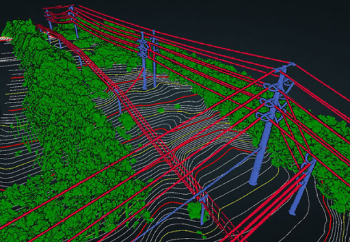
"We recently completed a LiDAR assignment for a large electric utility client in the Northeast. A transmission line installed decades ago needed to be replaced and part of it required being rerouted through a coal mine. In the past, a feasibility study to start a project like this would have involved negotiation, digging through coal, engineering, and planning. By flying over the site with our LiDAR drone, we were able to view and analyze accurate ground imagery and existing ground contours. What would have taken several months was done in less than two weeks," said Surveyor and CAD Manager, Bud Miller.
What it really comes down to is adding another tool to the toolbox. Having state-of-the-art technology is one thing. Being able to use it effectively is another. RTR utilizes a proprietary mobile app to record flight data and instantly alert the pilot if the drone is within five miles of an airport. The team is also known for their faster turnaround times. While most vendors take weeks or months to process the data, RTR can turn around most projects in a matter of days.
About RTR
RTR brings extensive experience coordinating the planning, management, and execution of projects in a variety of sectors. The highly skilled team employs extensive QA/QC procedures that have received high praise from customers, which include Fortune 500 companies.
Contact
Jay Parikh
Corporate Marketing Manager
jayp@rtrenergysolutions.com


 Animation, 3D Art and 3D Models")