


Highlights:
- Provides 3X spectral coverage; 4X resolution; 5X faster than previous generation of satellites
- Strengthens NOAA’s environmental and weather monitoring
- Heralds next generation of weather satellite technology, accuracy
MELBOURNE, Fla. — (BUSINESS WIRE) — February 23, 2022 — L3Harris Technologies’ (NYSE: LHX) third high-resolution weather instrument is set to launch March 1 onboard a NOAA satellite – strengthening the nation’s ability to monitor the environment and rapidly detect severe weather.
This press release features multimedia. View the full release here: https://www.businesswire.com/news/home/20220223005987/en/
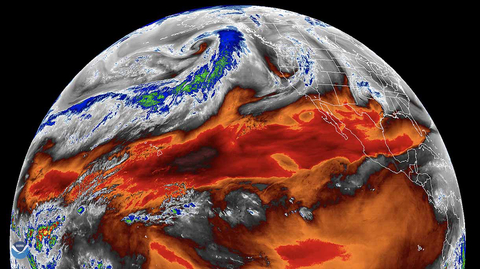
Atmospheric river flowing across the northern Pacific Ocean captured by L3Harris’ Advanced Baseline Imager onboard the GOES-West satellite. Credit: CIRA/NOAA
The Advanced Baseline Imager (ABI) is the primary instrument for the Geostationary Operational Environmental Satellite-T (GOES-T), the third in a series of four advanced geostationary weather satellites with L3Harris' ABI onboard. The ABIs are controlled by L3Harris' enterprise ground system.
The ABI provides high-resolution video of weather and environmental systems using 16 spectral bands delivering three times the amount of spectral coverage, four times the resolution and five times faster than the previous generation of GOES satellites. The Advanced Baseline Imagers on NOAA's two current geostationary operational satellites, GOES-East and GOES-West, enable more accurate meteorological forecasts, greater ability to study and monitor climate change, and allow experts to provide early warnings of severe weather conditions such as tornadoes, wildfires, and hurricanes.
“L3Harris' ABI has helped NOAA improve detection of wildfires, tornadoes and other extreme events that threaten lives,” said Rob Mitrevski, Vice President and General Manager, Spectral Solutions, Space and Airborne Systems, L3Harris. “We have been pioneers in space-based weather monitoring for more than 60 years and continue to set a high standard of capability with our Advanced Baseline Imager. We look forward to driving further forecasting advancements, as we continue our collaborative partnership with NOAA into the future.”
The company also announced the delivery of its fourth imager to NASA in late 2021. The fourth and final ABI was integrated into the GOES-U satellite last month and is slated to launch in 2024. GOES-U will complete NOAA's GOES-R series of advanced geostationary weather sensors and provides the groundwork for future Geostationary Extended Observations (GeoXO) imager programs, currently in the Phase A Formulation stage, with L3Harris underway with the next generation geostationary imager concept design.
About L3Harris Technologies
L3Harris Technologies is an agile global aerospace and defense technology innovator, delivering end-to-end solutions that meet customers’ mission-critical needs. The company provides advanced defense and commercial technologies across space, air, land, sea and cyber domains. L3Harris has more than $17 billion in annual revenue and 47,000 employees, with customers in more than 100 countries. L3Harris.com.
Forward-Looking Statements
This press release contains forward-looking statements that reflect management's current expectations, assumptions and estimates of future performance and economic conditions. Such statements are made in reliance upon the safe harbor provisions of Section 27A of the Securities Act of 1933 and Section 21E of the Securities Exchange Act of 1934. The company cautions investors that any forward-looking statements are subject to risks and uncertainties that may cause actual results and future trends to differ materially from those matters expressed in or implied by such forward-looking statements. Statements about the value or expected value of orders, contracts or programs and about system capabilities are forward-looking and involve risks and uncertainties. L3Harris disclaims any intention or obligation to update or revise any forward-looking statements, whether as a result of new information, future events, or otherwise.
View source version on businesswire.com: https://www.businesswire.com/news/home/20220223005987/en/
Contact:
Irene Lockwood
Space and Airborne Systems
Irene.Lockwood@L3Harris.com
585-465-3592
Jim Burke
Corporate
Jim.Burke@L3Harris.com
321-727-9131


 Animation, 3D Art and 3D Models")