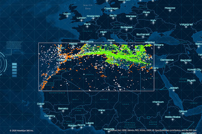
The Regional Awareness Subscription service delivers daily signal geolocation data for large regions
HERNDON, Va., July 28, 2020 — (PRNewswire) — HawkEye 360 Inc., the first commercial company to use satellites to create a new class of radio frequency (RF) data and data analytics, today announced that it is offering a daily Regional Awareness Subscription (RAS) service. Leveraging the company's RFGeo product, RAS delivers mission-critical insights by allowing organizations to identify, monitor, and analyze signal behavior over time. Large-scale RF signal mapping provides deeper situational awareness in these regions, with the data sets enabling trend analysis using traditional and artificial intelligence algorithms."We're offering a massive collection of data across a broad area. We are also enabling organizations to access periodic data and analytics for areas they want to monitor," said Tim Pavlick, VP of Product, HawkEye 360. "Subscribers will receive a daily collection of RF data, allowing them to gain comprehensive insight into their regions, establish historical analysis, and augment other geospatial intelligence solutions."
HawkEye 360 will work with customers to define a Regional Awareness Subscription that can span millions of square kilometers. Current RAS collection areas include the Mediterranean, South China Sea, and the Korean Peninsula. HawkEye 360 curates a collection plan that routinely gathers a combination of high-demand signals. The company delivers the data in an open standard GeoJSON format that seamlessly integrates with most applications.
"With our Regional Awareness Subscription service, we provide customers with a dependable source of timely, trusted RF signal insights that have been detected, characterized, and geolocated over the region," said Alex Fox, EVP Business Development, Sales and Marketing, HawkEye 360. "These insights allow our customers to identify, understand, and respond to activities important to their operations more effectively."
HawkEye 360's RFGeo product identifies and geolocates RF signals collected by HawkEye 360's proprietary satellite constellation. RFGeo is the first commercially available product offering global spectrum awareness across a broad range of radio signals. HawkEye 360 plans to expand the RAS offering to include new areas of interest important to customers.
Go to www.he360.com to learn more and contact HawkEye 360 about the RAS service.
![]() View original content to download multimedia:
http://www.prnewswire.com/news-releases/hawkeye-360-announces-a-global-radio-signal-monitoring-service-301100987.html
View original content to download multimedia:
http://www.prnewswire.com/news-releases/hawkeye-360-announces-a-global-radio-signal-monitoring-service-301100987.html
SOURCE HawkEye 360
| Contact: |
| Company Name: HawkEye 360
Media: Adam Bennett, Product Marketing Director Email Contact +1 (571) 203-0360 |


