


New MapBrowser provides roof-pitch, height, width and area tools to help companies measure rooftops and structures without onsite inspections; gives small businesses the same advantages as large companies to improve planning and presentation workflows
SOUTH JORDAN, Utah — (BUSINESS WIRE) — October 3, 2018 — Nearmap, a premium global location content provider specializing in high-resolution aerial maps, today introduced a complete measurement toolset in MapBrowser™ for the solar, roofing and other rooftop industries. The new tools allow users to measure roof-pitch, height, width and area, enabling roofers and solar installers to confidently measure rooftops and structures from high-resolution oblique aerial images.
This press release features multimedia. View the full release here: https://www.businesswire.com/news/home/20181003005645/en/
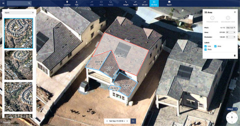
New Nearmap MapBrowser provides roof-pitch, height, width and area tools to help companies measure rooftops and structures without onsite inspections. (Photo: Business Wire)
The new MapBrowser helps customers significantly reduce onsite visits during the quoting and planning stages of projects and complements their remote roof/site inspection workflows, giving many small businesses the power of expensive systems that only large companies use.
Tony Agresta, Executive Vice President of Product, Nearmap, said, “Gone are the days of climbing on roofs to take measurements. Delivered to the cloud within days of capture, our aerial imagery allows roofers, solar companies and other small businesses to carry out assessments from the comfort of their office. Once the domain of large companies, the new features provide businesses of all shapes and sizes with the tools they need to save time, plan and estimate more accurately at a fraction of the price.”
Using Nearmap’s new tools, roofers and solar companies will be able to:
- Prospect more efficiently by viewing and expanding opportunities through aerial maps instead of other, more traditional ways.
- Process leads more quickly by qualifying prospects prior to visiting a potential job.
- Reduce costs associated with the qualification and proposal stages.
- Create better proposals using up-to-date, high-resolution photos, giving companies a better chance at winning a client’s business.
- Close more sales with the most accurate and competitive quotes.
- Increase revenue without adding systems or headcount.
Businesses in construction, home building, painting, insurance and other industries can also benefit from these new tools to accurately measure areas on properties in three dimensions. Nearmap’s aerial imagery can help users to show context for work being done, and the imagery can be annotated with notes, drawings and measurements that provide details of the plan.
Nearmap Oblique imagery can be accessed through a standard web browser using Nearmap’s intuitive MapBrowser application. In addition, Nearmap Oblique photos are published at sub-7.5cm Ground Sampling Distance (GSD)—better than satellite imagery—which allows users to see great detail.
About Nearmap
Nearmap brings the real world to you. Nearmap delivers high-resolution aerial imagery as a service to businesses across the world, powered by industry-leading geospatial mapping technology. Using its own patented camera systems and processing software, Nearmap captures wide-scale urban areas in the U.S., Australia and New Zealand multiple times each year, making fresh content instantly available in the cloud via web app or API integration.
Every day, Nearmap helps thousands of users conduct virtual site visits for deep, data-driven insights—enabling informed decisions, streamlined operations and robust bottom lines.
Founded in Australia in 2007, Nearmap is one of the ten largest aerial survey companies in the world by annual data collection volume and is publicly listed in the ASX 300.
View a current project in Nearmap today. For more information, visit https://go.nearmap.com.
View source version on businesswire.com: https://www.businesswire.com/news/home/20181003005645/en/


 Animation, 3D Art and 3D Models")