


ArcGIS Indoors Will Modernize Corporate Facilities, Retail Stores, Airports, and More, by Offering Interactive, Real-Time Mapping
REDLANDS, Calif. — (BUSINESS WIRE) — July 9, 2018 — Esri, the global leader in location intelligence, today announced it will release ArcGIS Indoors, which will enable interactive indoor mapping of corporate facilities, retail and commercial locations, airports, hospitals, event venues, universities, and more. By applying the latest location technology, ArcGIS Indoors makes life easier for employees, customers, travelers, and visitors by allowing them to see and share where assets, rooms, departure gates, and offices are located. This information, combined with navigation, scheduling, and analytic capabilities, will allow buildings to operate at an increased level of efficiency and safety.
This press release features multimedia. View the full release here: https://www.businesswire.com/news/home/20180709005245/en/
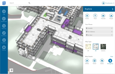
Esri announces a new indoor mapping product called ArcGIS Indoors. (Graphic: Business Wire)
ArcGIS Indoors uses data streams, real-time processing, and location intelligence tools to help businesses and other organizations understand how to better coordinate space and other resources with their facilities and campuses. Insights from sensor networks deliver real-time information to managers and executives through interactive dashboards, while visitors and employees can find useful information about the buildings they occupy. Floor-aware, 3D maps allow building operators and occupants to quickly access and explore critical business information, like the location and status of fire extinguishers and their last inspection dates, or conference rooms and their projector options.
"ArcGIS Indoors brings the interior building space into the future by placing data about employees, schedules, meetings, customers, and events into a geographic context," said Nitin Bajaj, product manager at Esri. "Having spatial awareness gives executives, managers, and employees better insight so they can operate more efficiently and competitively."
ArcGIS Indoors will be available for widespread use by the end of the year. However, a beta version of the product will be released at this year's Esri User Conference, to be held July 9–13 at the San Diego Convention Center in San Diego, California.
To learn more about how location intelligence is powering smart workplaces, visit go.esri.com/indoors.
About Esri
Esri, the global market leader in geographic information system (GIS) software, offers the most powerful mapping and spatial analytics technology available. Since 1969, Esri has helped customers unlock the full potential of data to improve operational and business results. Today, Esri software is deployed in more than 350,000 organizations including the world's largest cities, most national governments, 75 percent of Fortune 500 companies, and more than 7,000 colleges and universities. Esri engineers the most advanced solutions for digital transformation, the Internet of Things (IoT), and location analytics to inform the most authoritative maps in the world. Visit us at esri.com.
Copyright © 2018 Esri. All rights reserved. Esri, the Esri globe logo, ArcGIS, The Science of Where, esri.com, and @esri.com are trademarks, service marks, or registered marks of Esri in the United States, the European Community, or certain other jurisdictions. Other companies and products or services mentioned herein may be trademarks, service marks, or registered marks of their respective mark owners.
View source version on businesswire.com: https://www.businesswire.com/news/home/20180709005245/en/
Contact:
Esri
Karen Richardson
Public Relations
Mobile:
914-841-3180
Email:
Email Contact


 Animation, 3D Art and 3D Models")